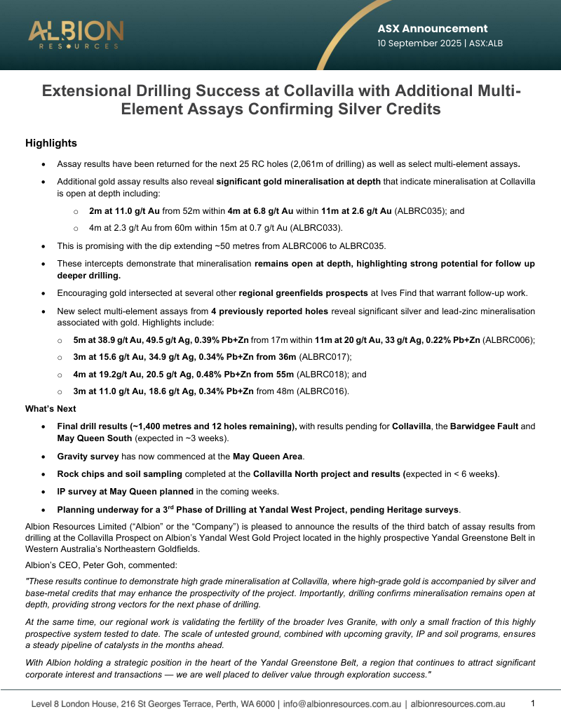
ASX drill results
Interpret ASX Results Properly
Turn drill headlines into source-linked geological evidence before judging the result.
Source Report
Report Visualisation
Loading visualisation...
You know the headline.
A company releases a drill result. The intercept looks strong. The market reacts. Everyone starts reading the number.
But the real question is not whether the interval sounds impressive.
The real question is: what did this hole actually prove?
That answer depends on more than grade and metres. It depends on collar position, dip, azimuth, interval selection, units, coordinate system, nearby drilling, and the geological idea being tested.
An ASX announcement is disclosure. Your job is to turn that disclosure into evidence.
That means placing the hole before judging the result.
A drill result is not a number
The headline intercept is designed to travel.
10 metres at 5 g/t gold is easy to repeat. It is also easy to misunderstand.
A drill result is a relationship between facts:
where the hole started
which direction it was drilled
how steeply it was drilled
which interval carried the grade
what units were reported
what coordinate system was used
what nearby holes already showed
what target the hole was testing
Strip those relationships away and the intercept becomes a floating number.
It may still be good. It may still matter. But you cannot know until you can place it in space.
Use this rule: never judge a drill result until you can place the hole.
The PDF is not your workflow
ASX announcements are built to disclose information to the market. They are not built to be your analytical workspace.
The collar table may be in one place. Assays may be somewhere else. Survey details may be in an appendix. The best context may sit in a map, a footnote, or a previous announcement.
That does not make the disclosure bad. It means the document has a different job from your analysis.
The PDF tells you what was released.
It does not automatically give you a dataset you can query, map, section, or compare.
Place the hole first
Start with the collar.
If you do not know where the hole started, you do not know where the result came from. A strong intercept in the right place can extend a system. The same intercept somewhere else may only repeat known ground.
Then check the direction.
Drill holes have dip and azimuth. Some also have down-hole surveys. An interval is measured down the hole, not automatically across the true width of the mineralised body.
The practical question is simple: did the hole cut across the target, or did it run along it?
That distinction can change the result.
Read the interval, not just the headline
Assay intervals need from-depth, to-depth, grade, units, and context.
Ask the boring questions first:
Is the interval part of a broader mineralised zone?
Was it selected from a longer lower-grade run?
Are there several narrow high-grade zones?
Are lower-grade or barren intervals shown?
Is the width down-hole or interpreted true width?
The headline interval is usually the cleanest summary. Treat it as the starting point, not the conclusion.
Units can quietly change the story
Grade columns only mean something when the commodity, unit, detection limit, and reporting basis are clear.
Gold may be reported in grams per tonne. Base metals may appear as percentages or ppm. Lithium, rare earths, uranium, and other commodities bring their own conventions.
This matters most when one announcement mixes elements, prospects, drilling, and surface sampling.
Do not let a familiar table shape make you careless. Check what the numbers actually measure.
Coordinates are evidence
Coordinates look precise. That does not mean they are immediately comparable.
Australian exploration data can move between datums, MGA zones, historical coordinate systems, and local grids. Current company data and government open-file data do not always line up cleanly.
A quiet coordinate error can distort everything downstream.
A step-out can look larger than it is. A trend can look cleaner than it is. A historical hole can appear irrelevant when it is actually central.
Coordinate handling is not clerical work. It is part of the evidence chain.
Old holes change the meaning
A new drill result rarely stands alone.
Earlier holes may show whether the company extended the system, filled a gap, repeated known ground, confirmed a model, or contradicted the old interpretation.
That is where context changes judgement.
A modest result can matter if it lands in the right structural position. A spectacular result can matter less if it simply repeats an area everyone already understood.
The question is not only what the new hole hit.
The question is what the new hole changes.
Keep the source attached
When you extract a table, do not detach it from the announcement.
You need to know where the data came from, what assumptions were stated, which notes qualified the interval, and whether the result needs checking against the original table.
Clean data without source context can feel more certain than it is.
Source-linked data keeps the evidence close enough to inspect.
Why careful readers still lose time
Most serious investors, analysts, and geologists already know these checks matter.
The problem is time.
A proper manual workflow means downloading the announcement, finding the right tables, joining collars to assays, checking units, handling coordinates, comparing historical work, plotting the holes, and returning to the source when something looks wrong.
That is manageable for one announcement.
Across a watchlist, a busy reporting day, or a large coverage universe, it becomes the bottleneck.
Under pressure, readers lean too heavily on the headline, the company's selected figure, or someone else's quick summary.
The evidence loop gets shortened.
Good research is not about reacting fastest to the headline. It is about getting to the right evidence fastest.
What useful extraction should do
A useful mining data system should do more than pull text from a PDF.
It should rebuild the relationships that make the result meaningful:
detect the relevant tables
classify collars, surveys, assays, and notes
normalise fields and units
connect intervals to the right holes
preserve coordinate information
keep source links attached
make the result usable for spatial reasoning
The output should help answer practical questions.
Show me the new holes. Show me where they sit against old drilling. Show me the assay intervals in 3D. Show me the project sequence over time. Show me the original disclosure when something needs checking.
That is the difference between having a PDF and having usable geological evidence.
Where Canetoad fits
Canetoad is built for the gap between public disclosure and usable geology.
It does not replace judgement. It gets the evidence in front of your judgement faster.
For an ASX drill announcement, Canetoad is designed to turn reported information into structured spatial context: collars tied to holes, assays tied to intervals, coordinates handled carefully, current results compared with historical work, and source links kept close.
The point is not to let software decide whether a result is good.
The point is to ask better questions sooner.
If a hole extends a trend, you should be able to see it. If it repeats known ground, you should be able to see that too. If the coordinate reference is unclear, the source should stay close enough to verify.
Faster evidence. Not blind automation.
Read the next result this way
When the next drill result lands, do not start with whether the headline sounds exciting.
Start with the evidence chain.
Ask:
Where is the collar?
Which way was the hole drilled?
What interval carried the grade?
What units and assumptions were used?
Which coordinate system anchors the result?
What did nearby holes already show?
Does the result change the geological interpretation?
If you can answer those questions, the announcement becomes useful.
If you cannot, the headline is only the beginning.
Good mining research does not treat the PDF as the final object. It treats the PDF as raw disclosure that must be turned into usable geology.
That is the work Canetoad is built to compress.
ASX drill result FAQs
Turn disclosure into evidence.
Use Canetoad to move from public disclosure to source-linked geological context faster.